Antarctica is losing its ice three times faster than just six years ago, raising fears the frozen continent may not be that way for much longer.
"The sharp increase... is a big surprise," said professor Andrew Shepherd of the University of Leeds, who led the latest research.
While it takes 360 billion tonnes of ice to raise sea levels just one millimetre, the reality is Antarctica has a lot of ice - 30 million cubic kilometres of it, a bit more than 30 quintillion tonnes.
That's enough to raise sea levels by 58 metres.
Here's what a 58m sea level rise will do to New Zealand.

Most of central Auckland is gone, with only Newmarket, Epsom and Mt Roskill poking out of the flood. Mt Albert is now a peninsula, and Mt Wellington an island.
The rest of the super city area resembles Fiordland, with streams overflowing their banks in spider-like fractal patterns.
Further north, Cape Reinga now sits at the top of an an archipelago. Whangarei is underwater, Red Beach now sits a couple of kilometres offshore on the seabed, Helensville too. Titirangi is now a port town, the gateway to the Waitakere Ranges.
South Auckland is almost completely wiped out, now pretty much just Totara Park.


All that's left of the Tauranga region is Mt Maunganui, sticking out of the expanded Pacific Ocean as a reminder of humankind's folly.
But that's the risk we took building a city on the sea's edge.
What about Hamilton? Well, it turns out the 'city of the future' might not have one.
Water from the Firth of Thames will flow right over the Hauraki Plains and drown the 'Tron completely. Cambridge to the south will emerge largely unscathed, with the water - let's name it Waikato Bay - spreading down to the city's direct south and enveloping Te Awamutu and Otorohanga.
The Coromandel remains a peninsula, just a lot skinnier than before.

While the central North Island remains dry, heading south we soon find more of New Zealand's biggest towns underwater - Hastings and Napier are both goners, Gisborne and Wairoa too.
Around Mt Taranaki, New Plymouth, Patea and Whanganui are also deluged.
Even Palmerston North doesn't escape the great flood, with the ocean swallowing most of western Wairarapa, including Levin, Shannon and Foxton.


Wellington fares better than Auckland and Hamilton, its hills finally paying off - at least for the western half of the city. Kelburn, Brooklyn and Karori all stay dry, as do Ngaio, Khandallah and Johnsonville in the north.
Petone, Lower Hutt and Naenae on the other hand - hope you can swim.
The region's unique geography means Upper Hutt residents who live on the east side will now have access to a bay, unfortunately those in the west will be in said bay.

Nelson, Blenheim and Richmond are all under water, as are Westport and Kaikoura.
Meanwhile Christchurch is now a strait, separating the mainland and Banks Peninsula.
Timaru, Invercargill and Haast are all underwater, by virtue of their proximity to the ocean. But Dunedin, like Wellington, is a city split in two - the east wet, the west dry.


Stewart Island is now two separate islands, with a strait joining Mason Bay and the Paterson Inlet.

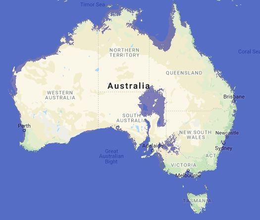
Since most Aussies live in cities near the coast, very few of them will be able to stay where they are. Perhaps they can move to the outback? It's predicted a massive lake about the same size as the North Island will appear in northeastern South Australia.

Newshub.
